LATERINA, PERGINE VALDARNO, BUCINE
Because of its riches, the Valdarno to the north of Arezzo was the theatre of bloody conflicts for the control of Tuscany between the Florentine Ghibellines and the Aretine Guelphs at the end of the Middle Ages. Indeed, in this territory at the end of the 13th century, the bishops of Arezzo possessed powerful and well fortified castles from which they could wage war on the territory of Florence. The Florentines, for their part and for their own defence, constructed three terre murate, or walled settlements in this valley, San Giovanni, Terranuova and Castelfranco. However, already in 1327 with the death of Bishop Guido Tarlati, the inexorable decline of Arezzo had set in so that, before the century was out, the city and its territory were subjugated to the control of Florence.
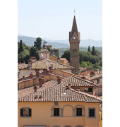
After you leave the city, the road crosses the River Arno and, going in a north-easterly direction, reaches LATERINA, a small township which grew up from the 11th century onwards and which, in 1272, was taken over by the Arezzo Commune as a means of blocking the expansion of Florence. Laterina stands on a hill where it can dominate the valley, and its centre is perfectly preserved. A perimeter of walls marks off the township whose oldest section is divided up by three parallel streets. The middle street, Via di Mezzo, leads off towards Rocca in the east and towards Torre Guinigi in the west. In the centre stands the Chiesa dei Santi Ippolito e Cassiano, its name taken from an ancient pieve that once stood in the village. On its exterior, you can see a fragment of Roman mosaic which came from the ancient pieve and, inside, the Madonna with Child between St Hyppolitus and St Cassian, by Domenico Puligo. Now take the Via Vecchia Aretina and, just outside Laterina, you can see the majestic Villa di Monsoglio with its rooms richly decorated with frescoes and with an Italian garden. The road crosses the river again and continues to PERGINE VALDARNO whose territory together with the territory of Laterina, Montevarchi and Terranuova skirt the Natural Park of the Valle dellInferno e Bandella, or the Valley of Hell and Bandella. Already a castle in the 11th century, Pergine originally belonged to an Abbey, Badia a Prataglia, and then passed in the 12th century to another, Badia di Agnano, but after the mid-14th century it was under Florentine domination. In the township, there is the Church of St Michael Archangel and the Museum of Industrial Archeology.
From Pergine, you take the road for BUCINE with its ancient centre and castle situated on a hilltop alongside the rivulet Ambra. Traces of the walls are still visible and a building in Via Castello, numbers 15-17, retains a structure that is believed to be part of the citadel of the Guidi Counts. At the top of the castle is the ancient pieve of SantApollinare which was partly ruined in 1710 and became a chapel. The Chiesa di San Giovvani Battista, instead, was probably commissioned by a member of the Conti family of Florence, the same family who enlarged it in 1581. The airy interior is interesting because of the grey sandstone columns that separate the nave from the two aisles. The capitals are surmounted by a Brunelleschi-inspired cube which bears the Conti coat-of-arms.
In POGI, a locality of Bucine, in addition to the parish church dedicated to St Donatus and the few ruins of the castle that was once the domain of the Guidi Counts, there is a famous Bridge over the Ambra. Built in hog-back style and of Romanesque construction, it rests on even more ancient foundations. After Bucine, the road proceeds to the PIEVE DI GALATRONA, also called Pieve di Petrolo, dedicated to St John Baptist. Although erected above a very ancient church, the present-day building goes back to 1324, while the façade in limestone and sandstone and the belfry show signs of the 16th-century renovations. With its nave and two aisles, the church possesses a splendid glazed terracotta Baptismal Font with Episodes in the Life of St John Baptist in the panels, by Andrea della Robbia. He was commissioned by Leonardo Bonafe to make the font in 1516, and also the ciborium on the high altar. Opposite the church and enjoying a magnificent panorama is the Fattoria di Petrolo, standing in a slightly more elevated situation, with its beautiful manorial Villa built in the early 18th century. You can easily reach the top of the hill by car and see the solitary tower which dominates the slopes of the Valdarno and the crests of the Monti del Chianti. It is all that remains of the Castle of the Guidi Counts which, after it had passed into the hands of the Tarlati family, eventually became part of the dominion of Florence in 1335.
|
|
|
|